We were up early and quickly headed to the town's bar & grill for breakfast. Our waitress was the same young lady who tended bar at the pizzeria the previous night. When the troupe of actors is small, each one needs to play more than one role.
The day was cool but comfortable, with rain showers visible in the distance as we started. On the way to Jackson Hot Springs, a caravan of 50 antique cars passed us going the other direction. Each one waved and most gave us a sample of their oogah horn. When we reached Jackson, of course there was no sign of the feared Rainbow People. At Jackson we picked up sandwiches for lunch somewhere in the lonely miles ahead.
After a few miles of easy upgrade, we started a five-mile climb to the first of the day's two mountain passes, Big Hole Pass at 7400'. It was a steady but sustainable climb until the steeper last two miles. We had to stop several times to catch our breath. For any reader who is a cyclist, let me put it in perspective: we did this same ride on a tour twelve years ago, and my memory is that we climbed this pass easily. More important than the twelve years that we are older, riding unsupported (carrying our own gear) is a huge difference on climbs. Our trailer and cases and contents are about 80#, and even so we are compulsive about not carrying anything not absolutely necessary. A week ago we collected everything we thought was expendable weight to mail home, and it only came to 1 1/4 pounds.
A descent of 1500' over 12 miles took us to the foot of the second climb, up to Badger Pass at 6700'. Before starting up, we stopped and ate our sandwiches. I later discovered that my bike computer was gone, doubtlessly at that lunch stop when the bike fell over. Anyway, the climb to Badger Pass was difficult, mostly because we were pretty thoroughly depleted, despite the lunch. Another 20 miles of mostly downhill took us to the large town of Dillon. Our total for the day was nearly 70 miles, with plenty of hard climbing. We discussed taking a day off at Dillon, but a good dinner and a soak in the motel's hot tub revived us.
Wildlife notes: Around Wisdom we saw first one, then many, yellow-headed blackbirds. I don't think we'd ever seen them before, and I would remember, because they are spectacularly beautiful. They are common in an uncommon habitat, fresh water marsh. Later in the day we saw a badger, which ran along side us for about 100 yards before reaching a hole where he could hide. And we saw our first three pronghorns, confirming that we are out where the deer and the antelope play.

East Ever Eastward! Touring America by Tandem Bike 2013
Tuesday, June 25, 2013
June 25 Dillon to Sheridan
We're having a problem with blogspot software, so I'll make a few notes and flesh them out when I can.
June 25
Easy recovery day from Dillon to Sheridan, 38 miles,
Green flat valley with ranches much closer together than Big Hole Valley yesterday.
Lots of hayfields.
Passed Beaver Head Rock which Sacagawea recognized from her childhood before she was kidnapped and sold by another tribe. Included in the first group of Indians Lewis & Clark met there was Sacagawea's brother.
Ruby Hotel, 1878. Refurbished but much still original. Not gentrified. Not at all.
Big climb tomorrow.
Bodies and spirits are healthy.
June 23- Sula to Wisdom, Montana
A heavy dew during the night left us with a frosty morning. To give the tent a chance to dry and the temperature to rise to a rideable level, we took our time over breakfast and breaking camp.
We had a long talk with a local rancher at breakfast. He bemoaned the two problems which have ruined his ranch for hunting. A fire in 2000, for which he blamed mistakes by the forest service, burned off 200,000 acres of forest in the area. Even now the mountains are bare, except for a little ground cover. Unless replanted, it will take hundreds of years for the forest to recover naturally. The other problem is wolves, which seem to be widely unpopular in Montana. As the population of wolves introduced at Yellowstone has grown rapidly, so also has their range. The rancher said they have cleaned out the game in southern Montana, and a lot of livestock as well. There is a federal program to reimburse ranchers for documented livestock kills, but wolves eat every scrap of what they kill, destroying the evidence, so to speak.
Once the temperature got up to around 50 degrees, we set out on a gently climbing grade for a few miles before tackling a major climb to a double pass. First we reached Lost Trail Pass at 7100', where we dipped back into Idaho for a short distance. We visited with the ranger there for a while, then rode back into Montana and up to Chief Joseph Pass at 7300'. We did the climb in good form, stopping every 300' of elevation gain for a breather.
From the passes, the road dropped about 1500' to the huge Big Hole Valley, a high, flat, grassy, empty expanse of cattle ranches, surrounded all around by high mountains, still snowy now.
We had planned to reach Jackson Hot Springs and camp there, since their lodge rooms were full. But we were warned that the annual Rainbow Gathering of many thousands of latterday flower children is near Jackson this year. Local experience was that theft and panhandling were serious problems. So we stopped 18 miles short of there at the crossroads town of Wisdom, pop. 101.
We didn't want to camp at Wisdom because mos quitos were swarming. The owner of the one little motel there was off somewhere and unreachable. But we found out about a cabin for rent, and it turned out to be a very comfortable place to rest and relax. After an excellent pizza dinner we were early to bed in anticipation of a long, hard day tomorrow.


Saturday, June 22, 2013
June 22- Hamilton to Sula, Montana
The ride today was only 35 miles, but puts us in position to do a long ride tomorrow, with two major mountain passes to climb over.
The route was simple, gently climbing along the Bitterroot River. The only place to stop in Sula has cabins, but they are all full today, so we are camping by a pond alongside the river. There is a store here so we don't have to live on granola bars. And they even have a hot tub where we enjoyed a long soak this afternoon.
While we ate lunch, we were entertained by a hummingbird feeder outside the window.
One other wildlife spotting of note: a few miles before reaching Sula we passed a bighorn sheep drinking from a puddle alongside the road. It scampered effortlessly up a steep cliff, but not before I snapped a picture, below. The sheep hadn't shed all of its winter coat, so it looked ragged. But it was nimble enough to reassure us that it was healthy.


Friday, June 21, 2013
June 21- Missoula to Hamilton, Mont
While doing my morning check on the bike, I discovered a broken bolt on the seatpost clamp. It left my seat and Sandy's handlebars free to swing back and forth, and the bike couldn't be ridden. But Missoula is only the second town on our route so far with a bike shop (Walla Walla was the other), and in fact there are a half dozen, including one only a block and a half from our motel. It didn't open until 9, so we hunted for a place to have breakfast, and stumbled across the Oxford Saloon. They not only offered breakfast, but were open at that hour. In fact, the place has been continuously open 24 hours a day since 1883, except one time in the '30's when there was a big fire in downtown Missoula. The bike shop was a little hole in the wall, and while we strolled around town for half an hour, the owner fixed our bike with a new part, very inexpensively. We had thought we might be stuck in town for a while, but we were on our way after a brief shopping stop for needed supplies. And by the time we were riding, the temperature had risen from its morning low of 39 to the high 50's.
The first 14 miles retraced our route from yesterday, along busy U. S. 12 to Lolo. We then continued down the Bitterroot valley on a bike path which had been built since we were here before, in 2001. The path took us all the rest of the 49 miles to Hamilton.
The rain we had two days ago left fresh snow on all the high ridges of the Bitterroot Mountains to our right all day, which made the scenery especially beautiful.
The route was nearly level, and the day was mostly sunny, so when we reached Hamilton we felt good and it was still only mid-afternoon. We were tempted to continue for another 20 miles to the next town, but that would have made us tackle a 7000' mountain pass late tomorrow when we were tired instead of early the next day when we were fresh. So here we are in Hamilton, where we enjoyed a good barbecue dinner. Alas, the motel's hot tub is closed for non-compliance with handicapped accessibility. I guess that's reasonable, but a soak would have felt good.
Pictures: The Oxford Saloon, Sandy in the Oxford Saloon, and Sandy studying the route map with the Bitterroot valley and a snowy peak behind her.


June 20- Lolo Hot Springs to Missoula
Still cloudy and dripping rain when we started down the mountain from Lolo Hot Springs, with the temperature at 44. The first couple of miles were cold, but we pedaled to keep warm despite the slight downgrade, and as we dropped elevation and the day warmed, it was easy riding for the 26 miles to the town of Lolo. Then it was a level 14 miles to the center of Missoula, with heavy traffic along the highway, but a wide shoulder to ride on.
At Missoula we stopped at the headquarters of Adventure Cycling Association. We've been members for many years, and after a couple of weeks of living intimately with the maps they produced, we feel a special kinship with that organization. They treated us very hospitably, taking our picture, giving us a tour of their newly expanded building, and even giving us free ice cream- another benefit from our dues! While there, we again ran into the young trio we met about a week ago, two sisters and a young man carrying a gun, on their way to the east coast.
From here, our route for several days will be one we rode on a group tour about 12 years ago. We know it will be beautiful and full of challenging mountain climbs.
Wednesday, June 19, 2013
June 19- Lochsa Lodge Id to Lolo Hot Springs, Mont
Today was our first rainy ride. We started in a drizzle with the temperature in the 50's. Within a couple of miles, a big black wolf suddenly appeared on the road about 200 feet ahead of us. He loped off into the woods. It was the first wolf we have seen in all our travels, except once through a telescope at Yellowstone.
We climbed 13 miles to Lolo Pass at 5230', and entered Montana and the mountain time zone. For most of the climb the incline was 5-6%, which we could handle steadily. One stretch was steeper, and we stopped long enough to catch our breath.
Thoroughly wet and chilled, we took a long break at the Forest Service visitor center at the pass. The temperature there was 42 degrees, and it was still raining. We added layers of dry clothes before heading down the mountain, and then we were really cold. I thought there was a problem with the bike, but soon realized the wobble was from my shivering. It may have been our imagination, but we both thought we felt sleet.
Our plan had been to reach Missoula today, about 40 miles from the pass. But 7 miles down the mountain we reached Lolo Hot Springs and went no further. Lewis and Clark crossed Lolo Pass June 29,1806, and stopped at Lolo Hot Springs. If it was far enough for them, it was far enough for us.
We found shelter for the afternoon and night at an excellent lodge with indoor hot springs. After a good lunch and a long soak, we felt very good about ourselves for getting over our first major pass in good form and good spirits despite the rain and cold.
The pictures are Sandy at the pass and Sandy snuggling with a stuffed moose at the lodge.


Tuesday, June 18, 2013
June 18- Wilderness Gateway to Lochsa Lodge, Idaho
At our campsite, Sandy served up a delicious breakfast of dried fruit and nuts, with beverages of water and imaginary coffee.
The day's ride was simple: we continued up U.S. 12 along the Lochsa River, rising from 2300' to 3800' over 40 miles, with nothing at all along the way except beautiful scenery. We were worried we might run out of water, but we didn't. With our fuel tanks nearing empty, we were grateful that the climbing was minimal.
We reached Lochsa Lodge in time for lunch. The comfortable and large lodge dates from the 20's. We have half a cabin with a king sized bed and a private bath- beats the hell out of camping with cold water and no showers!
This is day 13 of our ride, and our run of good luck with the weather has run out. From the lodge library we are watching storm clouds move through, and the forecast is for plenty of rain over the next several days.

June 18- Kamiah to Wilderness Gateway, Idaho
Adding to our growing list of interesting characters, we met a biker at the motel breakfast who'd ridden 700 miles from the Washington coast the previous day. He had been there to watch the start of the annual "unsanctioned" cross country motorcycle race. He raced last year and finished in 66 hours, 22 hours behind the winner. Easy enough to understand why the race is unsanctioned. This year's field was thinned out when seven riders were caught in a small town going through a red light at 70 mph in a 35 zone.
He'd lost a bag the previous day along the road ahead and was going to look for it.
Our route took us gradually up along the Clearwater River to Lowell, where we had planned to stop for the day. But feeling rested and restless, we decided to eat a good lunch there and stock up food for camping after 25 more miles. No motels, restaurants or stores ahead for 65 miles.
Lowell is where the Selway and Lochsa Rivers join to become the Clearwater River. Our route took us gradually uphill along the Lochsa, in a deep gorge with heavily forested mountains around us- beautiful country. The rivers are popular for rafting, and the Clearwater looked good for canoeing, too. But as we moved upriver the Lochsa became a constant cascade of rapids.
We saw a bald eagle swoop down to the river, but it left empty-taloned.
A few miles before our destination we ran across our biker friend with the "Here's Trouble" t-shirt. He'd had no luck finding his bag and his fancy leather jacket.
The riding was fairly easy despite the constant upgrade. A mile before we reached the campground, we stopped at the only other point of interest, an historic ranger station dating from the 1920's, now kept open as a museum staffed by friendly elderly locals. The fresh water available there was welcome.
Also welcome was the campground where we unwound after a long day in the saddle and dined on canned chicken, cheese and crackers, with granola bars for dessert. As soon as it was dark, we hit the hay.
Sunday, June 16, 2013
June 15- Clarkston WA to Winchester ID
We crossed the Snake River into Idaho and rode for 5 miles on a bike path along the river before starting a gradual climb from 750' to 2000' through hilly country with enough grass to support cattle and horses. A quick descent to 1200' was followed by more long but easy climbing.
32 miles into the ride we reached the little Nez Perce Indian town of Culdesac, where we had planned to stop for lunch and a rest, but the store/cafe was out of business. We filled our water bottles from a hose at an unmanned utility office, ate a couple of granola bars each, and headed up the hill toward our destination of Winchester. We climbed from 1700' to 3800' over five miles, but we quickly felt the lack of calories in our fuel tanks. It was slow going. We took many rest stops, and catching our breath was easy enough, but our legs were tired and short stops didn't help them much. It was a warm, sunny day, and twice on the climb I finished a water bottle, but was able to beg water from ranch houses. The road finally levelled out and we rode the last 7 miles to Winchester at 4200'. We found a room at a little lodge, the only surviving accommodation in a dying town of 300, and after a shower and some rest we walked two blocks to a saloon for a cool drink. Although it was Saturday night, we were the only ones there; the saloon's owner died last year, and the bartender is worried about the bar's future. Refreshed, we moved next door to a small restaurant which served us a surprisingly good basic steak dinner. Only 44 miles on the day, but 4300' of climbing. Bedtime was early, and we slept like stones.

June 16- Winchester to Kamiah Idaho
We woke with legs still tired and twitching from yesterday's hard ride, but they felt better after a hot shower and a rub.
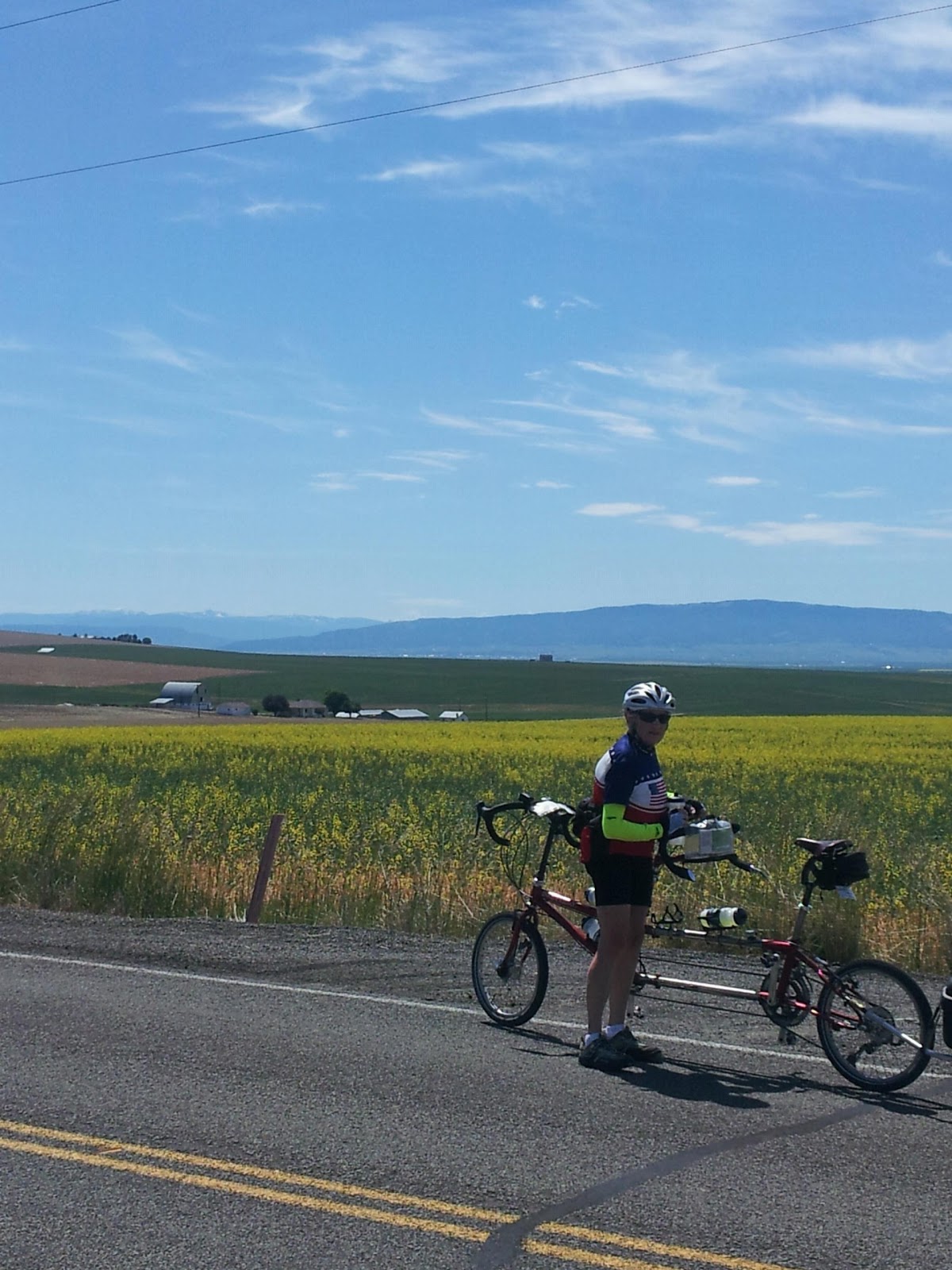
Today was a much easier, short ride. We rode through buttes (hills with rock outcroppings) and rolling hills with some ranches but mostly fields of wheat and canola. The yellow-flowered canola fields and green wheat fields made for very pleasant sights and scents as we rode along.
In the distance to the east, we can see the ridge of Bitterroot Mountains, which divide Idaho and Montana. There is still snow on many of the highest peaks. After a couple more easy days ahead, we'll tackle those mountains and climb to Lolo Pass.
The last 11 miles of today's ride were a fast downhill from 3300' to 1500' and the town of Kamiah, pop. 1000, which sports an Indian casino.
We saw several large white tailed deer today, and they were especially skittish. They may know more than we do about the dangers of humans.
Today's ride just 41 miles, with 1700' of climbing.
Saturday, June 15, 2013
June 14- Pomeroy to Clarkston WA
We started the day with a gadual climb from 1800 to 2800' over 10 miles before descending to the Snake River and into Clarkston. The terrain is desert, high rocky hills. The ride was only 30 miles, so it was effectively a half day off. We had planned on a day off once a week, but don't feel the need so far.
Clarkston WA and Lewiston ID are two gritty large towns flanking the Snake River at the limit of ship navigation from the Pacific.
As it was Flag Day and also our anniversary, we treated ourselves to a nice motel, complete with hot tub, and an excellent dinner at what several people said is the only good restaurant in town. When you here for only one meal, you only need one.
At one point in mid ride, we passed a historical marker pointing out an ancient Indian trail which Lewis and Clark followed on their way east, taking an overland shortcut from the Columbia to the Snake River, saving several miles. The trail is said to have been used for thousands of years, and can still be seen on the hillside. Can you see it?

June 13- Walla Walla WA to Pomeroy WA
The distance of our days' rides is partly set by the location of towns where we can stop for the night. Today was a fairly long haul, 66 miles plus another 5 in town here to shopping and dinner. Tomorrow, on the other hand, we plan to go only about 30 miles because the alternative is more like 80. So today was our longest so far, and also had the most climbing, 4000'.
Leaving Walla Walla this morning, the terrain was rolling, and instead of yesterday's desert, there were wheat fields as far as we could see. After about 20 miles we were back in desert/cattle country except for the green stripes along creeks. Our elevation gradually rose to 2100', but then gave 500' back on a fast descent to the small town of Dayton. There we met three 20-somethings also heading across the country by bike, two girls and a young man who was packing a large revolver "outside his pants for all the honest world to feel". They left a few minutes before us, but we quickly overtook them. One of the girls remarked on the tough hill we were climbing- she has some nasty surprises ahead of her.
The last part of the ride was steady but easy climbing in somewhat greener land, with wheat and other crop fields.
In Pomeroy we connected with a woman running a B&B, and relaxed over wine in her garden before riding to dinner. At the restaurant (THE restaurant) we met two men cycling cross country, hoping to finish in one month. One of them was icing a sore knee. Superstition keeps us from feeling too smug that our knees don't need that.
Pomeroy is a struggling town of 1500 with many nice Victorian houses and many closed shops.
For a few miles today we actually had a crosswind, breaking our perfect record of a sustained tailwind since we began. The weather is too good to last, but we are grateful for it.

Wednesday, June 12, 2013
June 12- Umatilla OR to Walla Walla WA
Today's 60-mile ride started mostly flat alongside the Columbia River. After 15 miles we crossed into Washington, leaving Oregon for good, and a few miles later the river turned north as we turned east. The photo is Sandy's view just before we said goodbye to the Columbia River.
Our route took us into Washington's wine country. Unlike other vineyards we've seen elsewhere, those here are in otherwise desert land, relying on irrigation for their water. The green spots in the brown landscape are spectacular.
Before reaching Walla Walla we stopped at the Whitman Mission National Historical Site. Dr. And Mrs. Whitman came out here from New York State in 1837 to found a mission to the Cayuse Indians. She was the first white woman to make the entire overland trip. The mission struggled for 12 years before the Indians decided that that the white men were a source of disease and a potential threat to their way of life (can't argue with that), and they killed the Whitmans and several others. Between recriminations and more disease, the Cayuse became almost extinct.
Walla Walla is a very pretty town. The downtown area, has probably 30 wine tasting rooms for the various wineries, and also many wine bars.
After one week on the road we have logged 370 "map miles" plus another 30 miscellaneous miles. Our altimeter shows just over 16,000 feet of climbing and we haven't even reached the mountains. Our legs feel good and we are having fun.

Tuesday, June 11, 2013
June 11: Roosevelt WA to Umatilla OR
We slept pretty well last night for our first night camping. Although the wind howled all night, the tent held its ground. The sun rose shortly after 4 a.m., but all in all we awoke well rested after two short riding days. My dog bite wound looked OK this morning, and Yuri sent me off with some supplies of bandages and antiseptic.
When we started riding, the wind was blowing an easy 20 kts, out of the west as usual, and we were grateful for the tailwind. We rode about 50 fairly flat and uneventful (but fast) miles on the Washington side before crossing the river to Umatilla OR. We needed to cross back to Oregon because the Columbia turns north here and we are heading east, Our motel was two or three miles west of where we crossed, so it was a short hard pull into the wind to end to an otherwise easy 57 mile day. Once again, we finished early in the day, but we stopped because it is 50 miles or so to the next place with lodging.
June 10: Biggs to Roosevelt
An eventful day.
The only highway east from Biggs on the Oregon side is I-84, so our route Monday took us across the Columbia River into Washington. After a steep climb to the highway paralleling the river, we rode through rolling hills and empty, dry countryside. On the ridges above us were hundreds of giant windmill generators, and after a while wind farms appeared across the river in Oregon as well.
Along the way, we met a fellow cyclist by the name of Wag, who was on his way home to Idaho after riding to the Oregon coast. His MO is unusual: he rides until he gets tired, and then tries to hitch-hike with his bike. Although he is an older guy (almost as old as me) with a grey beard, he says he gets rides. We rode for a while with Wag. He is stronger on climbs, but on descents our tandem left him far behind.
After just 37 miles we reached the only likely stopping point on the Washington side of the river, the town of Roosevelt. Its claim to fame is that just over the hill is one of the world's largest landfills, where all of Seattle's garbage and trash goes. The little town itself is mostly dusty and junky, but there are also about a dozen large, modern houses. No motels, but the Corps of Engineers has a park on the river where we could camp. Up by the highway there was also a country store with a cafe, run by a very friendly older couple. After lunch Wag went off to try to thumb a ride, and we rode down to the park and set up our tent. Wag never showed up, so he must have been successful. The park is a popular spot with windsurfers and kite boarders, and we spent the afternoon chatting with some of them while they waited for the wind to pick up. About 5 p.m. it finally blew about 15 kts and we watched them sail out on the river.
We also met an amazing young couple, Yuri and Ika, who were traveling by bike and carrying more stuff than you could possibly imagine. I'll attach a pic of it all.They've been on the road a month and have come only 120 miles. One of their trailers had broken, so Yuri, who comes from Irkutsk in the far east of Siberia, was trying to fashion a jury rig to carry more stuff on the back of his bike.
We had been warned that the park turns on its sprinklers at night but that the camp host had deflectors we could place near the sprinkler heads to avoid getting our campsite soaked. The camp host was away, but later, when I saw him arrive back at his trailer, I walked over to ask him about it. As I approached, his dog came out from under his trailer on a dead run for me. I expected him to stop, as aggressive dogs usually do, but no such luck. He jumped up and bit my leg, knocking me down. As I scrambled up and back, he came at me a second time and bit my other thigh. Turns out, the dog is trained to ignore any contrary voice commands from his master and attack anyone who comes within the perimeter of his run, a rope about 40' long. Just the thing for a campground host, eh? The host said he used to have a warning sign, but someone took it.
Sandy and later Yuri, who is a former EMT, helped clean up my wounds, mainly the one on my left thigh. When we went up to the cafe for dinner, everyone there seemed to know about the guy and his dog, and they said they'd report it to the sheriff. As for me, I told the guy that if he put up a sign and if my leg doesn't get infected, I won't pursue it. He did put up a sign. Of course, if anyone asked my suggestion, I'd have the dog shot. Maybe the owner, too.


Sunday, June 9, 2013
June 9: Hood River to Biggs OR
Today's ride covered the western half of the Historic Columbia River Highway route and also the western part of the Columbia River Gorge. We awoke this morning to another clear day, with the wind blowing 15-20 mph from the west, giving us a strong tailwind all day. The Columbia River at Hood River is one of the windiest places in the U. S. People come from all over the world to windsurf there. But no one was on the river as we left this morning.
We started with a climb up a few switchbacks to the start of a bike-only stretch of the historic highway. Last year we cycled that segment on our car trip through the area, and also a few miles of the road to the east. Today, we continued climbing, with continuous beautiful views of the river below, to a spectacular overlook above Rowena, where we met three cyclists riding the same direction, who were training for this summer's annual ride from Seattle to Portland. They gave us some tips about the route ahead in Oregon.
Then it was a fast descent to The Dalles and the end of the Historic Highway.
At The Dalles, the scenery changed dramatically. The towering high cliffs along both sides of the river gave way to lower, rounder mountains. And the green forests farther west, which I mentally associate with Oregon, suddenly disappeared. The hills are brown and dry. Evidently we have moved past the wet coastal marine climate zone. And we have done so without any rain, except a few misty drops on our very first day.
After lunch at The Dalles, our route put us on I-84 for ten miles. We covered that pretty quickly with the highway's easy grades and the wind behind us, but we were still glad to finish the last interstate segment for a while. Big trucks roaring by a few feet away are unsettling. A few miles later we reached Biggs, which isn't more than a highway intersection with a very few fast food places and inexpensive motels.
We stopped at Biggs even though it was early in the day and we'd only covered 47 miles, because there is nowhere else within reasonable reach. From Biggs to the next town, Umatilla, is about 90 miles, with no motels and only one campground in between them. So we rested the remainder of today, and tomorrow's ride looks like a short one, to West Roosevelt's city park campground.
Total for the day, 47 miles with 2400' of climbing. None of today's climbs were leg-breakers. We can haul our gear up long 5% grades steadily, but at 10% we run out of steam fast. We'll just have to see how many of the steep ones lie ahead.
We are feeling good after four days on the road; legs a little sore but no signs of fatigue.
Sandy chatting with cyclists we met above Rowena:

Saturday, June 8, 2013
June 8- Troutdale to Hood River OR
Today was the first Saturday of our ride, and many cyclists and motorcyclists were out enjoying the beautiful weather.
As we left Troutdale a group of motorcycles passed us, and the lead on shouted "You're REAL bikers!". That's a first.
We started on the Historic Columbia River Highway, built in the years after WWI. It was the first modern highway in the NW, and the first deliberately scenic highway in the US, It originally extended about 70 miles along the river, but parts of the roadbed have become I-84. Some of what remains is the original beautiful winding narrow road, some a bikes-only road, and a few places are just for hiiking.
The first few miles were on the original highway, climbing a few hundred feet to scenic overlooks including the 1918 vista house. One of the photos below shows us at Vista House, taken by a Hong Kong Chinese man who was very interested in us and our rig, and asked if he could take pictures. The other is the view from another overlook just to the west.
The road descended to near the river level and passed several waterfalls including 600' Multnoma Falls, where we stopped for lunch at a lodge built at the same time as the road.
A few miles further the historic highway segment ended and our route map showed we had to ride 5 miles on the interstate, which is legal when there is no alternative. Soon after starting on the interstate, we noticed a perfectly good bike path paralleling it. So we lifted the bike and gear over the concrete barrier and rode that. Big mistake. As we rode along we started to notice debris and construction equipment which suggested the bike path wasn't really open. We knew that for sure when the path ended at a big pile of dirt awaiting grading. Having come so far, I decided to reconnoiter on foot and discovered that a short but difficult drag over the construction site led to a section of the old Highway. I am sure we were the first bike ever to traverse that new bike path.
Once again on the bike path we encountered a family on bikes who assured us that we could reconnect with our planned route at the next interstate exit.
A few miles later we came to an expected staircase where we had to unhitch the trailer and carry the bags, trailer, and bike down the stairs separately. Compared to what we had done a few minutes before at the construction site, the stairs were easy work.
The bike path soon gave way to a road which took us uphill at an 8-10% grade (we have a clinometer, so we know) for a little over a mile. We couldn't sustain that steep a climb with the load we're pulling; we had to stop to catch our breath several times. We'll surely have to do that many times in the weeks ahead.
Finally, the road ended and put us back on the interstate for the last 11 miles to Hood River. The only thing hard about that was that we had run out of water- a mistake we'll be vigilant not to repeat.
Finally at Hood River we had just enough time to drop off the trailer at a motel and ride to the local church for their 5:30 vigil Mass. At the end of the service. The priest, who had spotted our Florida cycling jerseys, singled us out and asked, "You're from Florida? Are you lost?" I answered that we were starting our cross country ride from Oregon. That got a lot of attention from the congregation.
Back to the motel for a delivered pizza and an early bedtime. The day's ride was 55 miles with 3800 feet of climbing.


Friday, June 7, 2013
June 7: St. Helens to Troutdale
After a fairly long day yesterday, today was easy riding, 49 miles in perfect weather, and only 700' of climbing all day. We followed Rte 30 about 20 miles to Portland. Getting through the city, even with our detailed route maps, supplemented by Google, was confusing. But we stumbled our way through the only large city on the whole route, and headed east along the Columbia River, with views of snowy Mt. Hood ahead. We rode past the Portland airport where we'd flown in on Tuesday. Lunch was corn dogs at a trailer park cafe, but don't pity us: read on. Reaching Troutdale, the western end of the Historic Columbia River Highway, by a slightly different route than the one suggested, we checked into a Comfort Inn and signed up for their rewards program (we'll run up a lot of points this summer). After a shower and a nap, we walked up the hill to the town's one street. Mostly craft displays, but there was one excellent Italian restaurant. We enjoyed a good meal and a bottle of Montepolciano, and retired for the evening refreshed and happy.
It looks like we'll have a short days in the week ahead, dictated by the space between places we can stop, and at least one camping night.
On the road- day 1
After months of planning and anticipation, we finally got on the road Thursday morning, heading east from Astoria, Oregon. But before describing our ride, Sandy says Astoria merits more of a mention, and I agree.
Astoria was the first town in the west, founded as a fur trading base at the mouth of the Columbia River by John Jacob Astor in the very early 1800's. In the late 19th century salmon canning became a major industry, and even now there remain several seafood packing plants along the waterfront. We visited Astoria last summer, and enjoy the pretty town. There is a 100-year-old trolley which runs along the riverfront, maintained and run by volunteers. It costs a whole dollar to ride, and makes a fun way to get around town. This year, we again spent time at the excellent Maritime Museum. Lots of good seafood restaurants at Astoria, too.
We were lucky with the weather. Usually cold and rainy at this time of year, our weather has been beautiful the last two days: partly cloudy and cool. Fine riding weather. The route along U. S. 30 went through wooded rolling hills with few towns along the way. The wind was light and behind us, so the riding was easy, with two 700' climbs with 5-7% grade. We felt good except for sore seats from having been off the bike so much for the last few weeks. Sandy called it "lazy bum syndrome." We reached St. Helens and found a comfortable motel right on the route. 69 miles for the day with 3300' of climbing. We ride about 2 mph slower than we would without the gear we're carrying, but the loaded bike handles well.
Wildlife: saw and heard sea lions at Astoria. Later passed one deer.
Wednesday, June 5, 2013
June 6- Our tour begins
June 6, D-day, for us stands for "departure".
After flying from Denver to Portland yesterday, we reached Astoria by bus. The driver kindly let us off right at the door of our motel. We assembled the bike, went next door for a bite to eat, and hit the sack after a long day of travel.
Today's ride might be considered a prologue stage. To check that the assembled bike is good to go, we rode a short distance out to the Pacific shore at DeLaura Beach, near Warrenton, and back to Astoria. Total 25 miles. The rest of the day was for sightseeing along the waterfront of Astoria, and visiting the local bike shop for new cycling gloves for both of us.
We don't know how much chance we will have on this trip to sample local food specialties, but today we did get a memorable lunch of smoked fish sandwiches (maple salmon for Sandy, sturgeon for me) on bagels with cream cheese.
We spoke with a group of fishermen on a nearby pier who were fishing for sturgeon. One of them caught and released a ten-footer yesterday, much bigger than the allowable size to keep.
Tomorrow we cut the cord and head east in earnest.
The photos are our official departure point and DeLaura Beach, and overlooking the mouth of the Columbia River at Astoria.

Subscribe to:
Posts (Atom)